In the rapidly evolving landscape of geospatial technology, effective solutions emerge from recognizing the distinct ways different professionals consume location intelligence. Today, we are proud to introduce the FSQ Spatial Product Family, a collection of specialized tools designed to move beyond the one-size-fits-all model. This new suite includes: FSQ Spatial Workbench for BI Analysts, FSQ Spatial H3 Hub for Data Scientists, FSQ Spatial Desktop for GIS Professionals, and the FSQ Spatial Studio for map makers and visualization experts.
The path to these specialized tools began with customer insights that would fundamentally reshape our platform approach. When we introduced the Foursquare Geospatial Intelligence Platform in Q4 2024, our vision was ambitious yet singular: create a unified platform that would democratize access to geospatial intelligence through integrated data, compute, and visualization capabilities. Built on three foundational pillars: [Data] pre-packaged datasets connected with H3 cellIDs & FSQ PlaceID, [Visualization] FSQ’s Kepler.gl variant for intuitive visualization, and [Compute] pre-provisioned compute engines optimized for geospatial workloads, the platform promised to transform how organizations leverage location data for business intelligence. As we began testing with a select cohort of customers, we discovered three distinct personas, each gravitating towards a different aspect of our platform based on their specific workflows and expertise:
- BI Analysts valued the intuitive workflow that guided them seamlessly from uploading their business data to generating spatial insights to publishing interactive dashboards and maps. They appreciated the pre-provisioned geospatial compute capabilities that handled complex spatial operations behind the scenes, while maintaining the flexibility to bring in their own datasets and enrich them with pre-packaged geospatial data. This allowed them to create compelling visualizations they could immediately share with stakeholders.
- Data scientists without a geospatial background appreciated the datasets pre-indexed to H3 cells, but wanted to leverage them outside of the platform in their own machine learning workflows. They needed a way to quickly enrich basic spatial attributes in their models—transforming simple lat/long coordinates or city names into rich feature sets including demographics, economic indicators, infrastructure accessibility, and environmental data. Additionally, they wanted access to a broader catalog of geospatial datasets beyond our proprietary offerings, all standardized and ready for feature engineering without requiring spatial domain expertise.
- Tech-savvy GIS professionals sought to overcome the performance bottlenecks of traditional GIS, but found that a browser-based platform was not the answer. For them, data sovereignty concerns and browser memory limitations make cloud-based solutions a non-starter for the massive local datasets their work requires. This created the need for a modern desktop application that combines high-speed analytics with fluid, GPU-accelerated visualization in a single, integrated environment, free from the constraints of the cloud.
These learnings led us to break down our initial product offering focused on enterprises into multiple offerings focused on distinct individual personas: FSQ Spatial Workbench for BI analysts, FSQ Spatial H3 Hub for Data scientists, and FSQ Spatial Desktop for GIS Professionals. Furthermore, this launch also marks our renewed commitment to open source. FSQ Spatial Studio will continue to serve as a free visualization playground and act as a bridge between our advanced Kepler.gl fork and the public open-source version, allowing us to showcase new features as we work to contribute them back to the community.
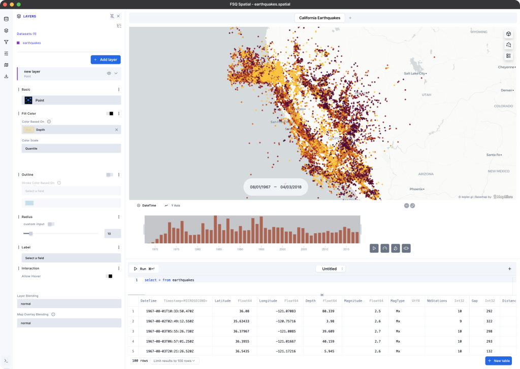
FSQ Spatial Workbench: Accelerating Business Insights With Spatial Data

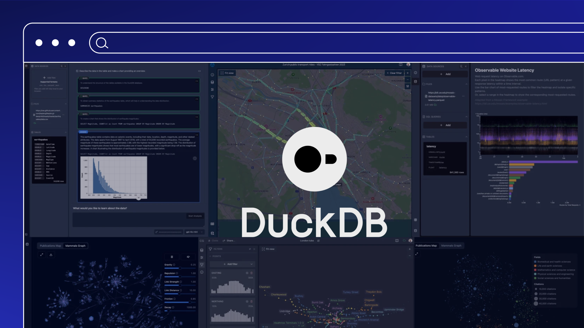
For the BI analyst, FSQ Spatial Workbench provides a streamlined path from business data to spatial insights through a familiar SQL-first interface. Analysts can load their business data into our pre-provisioned MotherDuck instances, perform spatial analysis through SQL queries with inline map visualizations, and seamlessly transition from exploratory analysis in SQL workbooks to creating publication-ready interactive Kepler.gl maps and dashboards.
Key Highlights:
- SQL-first spatial analysis workflow eliminates the complexity of traditional GIS interfaces.
- Pre-provisioned geospatial compute infrastructure removes spatial database setup barriers.
- Seamless transition from SQL exploration to publication-ready interactive maps.
Coming Soon:
- Ability to bring your own database to the platform using a set of connectors.
- Additional out-of-the-box compute engines tuned to geospatial workloads, such as Kinetica.
- Collaboration features for smaller teams and organizations.
FSQ Spatial H3 Hub: Making Geospatial Data Accessible For AI
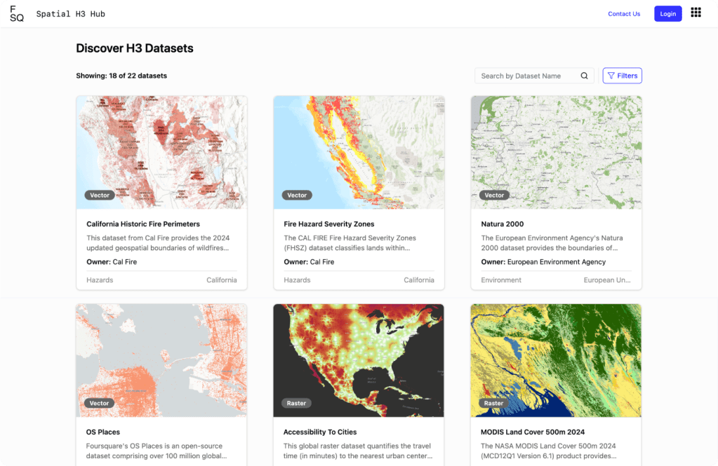
FSQ Spatial H3 Hub eliminates traditional barriers to geospatial data adoption in traditional ML models by providing data scientists with analysis-ready datasets that do not require specialized geospatial tools or expertise. Datasets containing information in raster and vector formats are converted to tabular form and indexed to H3 cells. This allows data scientists to easily enrich their own datasets, containing attributes like lat/long coordinates, city names, or zip codes, by joining on a common H3 index. Built on DataHub‘s enterprise metadata management system, the platform ensures data lineage tracking, versioning, and governance capabilities that enterprise data teams require. This foundation enables the first offering in the FSQ Spatial H3 Hub: an Iceberg Catalog that offers 20+ open datasets pre-indexed to H3 cells at resolution 8, made available in a free preview. Data scientists can access this catalog from their framework of choice (Spark, Python, DuckDB) and augment their ML models with a rich array of spatial features.
Key Highlights:
- Automated transformation of complex raster and vector data into analysis-ready tabular data.
- Democratized geospatial data consumption that eliminates traditional spatial domain expertise requirements.
- Location-to-feature transformation that enriches basic coordinates with demographic, economic, and environmental intelligence.
Coming Soon:
- Access to datasets indexed at a finer-grained resolution than H3 resolution 8.
- A service to index your own private dataset using our proprietary H3 indexing pipeline.
- A REST interface to access all the H3 features for a specific cell, for real-time workloads.
FSQ Spatial Desktop: Advanced Desktop Computing for Modern GIS
FSQ Spatial Desktop unleashes Kepler.gl from browser limitations by pairing its proven visualization excellence with native DuckDB on the desktop. GIS professionals who appreciated Kepler.gl’s capabilities but found it “gets limited fast” can now leverage the same GPU-accelerated visualization engine without WebAssembly constraints, browser memory limitations, or cloud dependencies. By combining Kepler.gl’s real-time rendering of millions of data points with native DuckDB’s sub-second spatial queries on multi-gigabyte datasets, professionals can perform complex spatial analysis and create compelling visualizations using familiar interfaces while maintaining complete control over their data. Built on the open-source SQLRooms framework, the platform enables community-driven extensibility through custom plugins while delivering the full computational power of desktop computing for performance-critical and visualization-intensive scenarios that browser-based tools simply cannot handle.
Key Highlights:
- Kepler.gl visualization freed from browser memory limitations and WebAssembly constraints.
- Sub-second spatial queries on multi-gigabyte datasets through native DuckDB.
- Complete data sovereignty with local analytical control and project persistence independent of cloud platforms.
Coming Soon:
- A Geospatial AI Assistant using Ollama-based local LLMs.
- A collection of plugins for add-on features.
Foursquare Spatial: A Geospatial Intelligence Platform Built on Open Standards

This launch represents our response to a fundamental insight: BI analysts, data scientists, and GIS professionals each require specialized computational approaches to spatial data, rather than adapting their workflows to universal platforms. By building on proven open-source foundations (H3, DuckDB, Kepler.gl, SQLRooms), we’re creating an ecosystem where innovation happens through community contribution while making location intelligence more accessible across the entire spectrum of data practitioners.
Explore the FSQ Spatial Products today:
- For the BI Analyst: Start Your Free FSQ Spatial Workbench Trial
- For the Data Scientist: Access the Free Preview of FSQ Spatial H3 Hub
- For the GIS Professional: Download FSQ Spatial Desktop
- For the Mapmakers: Try FSQ Spatial Studio for Free
Get started with Foursquare Spatial for better, faster location insights
Authored by: Vikram Gundeti